Earl heads to Bahamas as Fiona intensifies
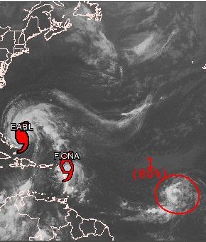 (CNS): As the hurricane Earl heads towards the Bahamas today, Fiona has begun intensifying and is now threatening the northern Leeward isles. Meanwhile, the NHC is predicting that another area of low pressure some 800 miles south east of Cape Verde has an 80% chance of becoming a cyclone. At 8am this morning Earl was 180 miles east of San Salvaldor in the Bahamas. With maximum sustained winds of 125mph, Earl is moving northwest at 16 mph. Earl is a large hurricane with hurricane force winds extending outward up to 90 miles from the centre and tropical storm force winds extend outward up to 200 miles.
Earl is expected to make a gradual turn to the north-northwest and the core of the hurricane will be passing well east and northeast of the Bahamas today and tonight and could approach the North Carolina coast by Friday morning.
Tropical Storm Fiona is about 70 miles Northeast of Barbuda and travelling at 15mph in a west-northwest direction.
Maximum sustained winds are at 60 mph with higher gusts and some slight strengthening is possible during the next 24 hours but the NHC said there would be little change in intensity after that.
Tropical storm force winds extend outward up to 140 miles mostly to the northeast of the centre. A gradual turn toward the northwest is expected to occur later today and on this forecast track the centre of Fiona should pass near or just north of the northernmost Leeward Islands later this morning and afternoon.
Meanwhile another storm is likely to develop over the next few days as the NHC said the area of low pressure south west of the Cape VerdeIslands has become more organised overnight and environmental conditions are favourable for development.

Category: Science and Nature
