Igor forecast to make direct hit on Bermuda
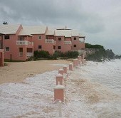 (CNS): According to reports from Hamilton,on Saturday, Bermuda is preparing itself for what the home affairs minster said was “probably the worst storm we have seen” as Igor a category two hurricane headed towards the island. With storm force winds stretching for 345 miles the NHC said Bermuda can expect to start experiencing the effects of Igor this evening. The Royal Gazette said that the country’s capital was quiet this morning as residents appear to have made their preparations and are ready to batten down as they wait for what is expected to be a direct hit. Igor is forecast to reach its closest point to the Island at 3am on Monday when it will be around 11 miles to the north of the Island.
The hurricane is currently about 400 miles south of Bermuda and moving at ten knots with sustained winds of 110 miles per hour with higher gusts. The NHC said it could not rule out Igor regaining Category 3 status before it reaches Bermuda as fluctuations in strength are expected and Igor remains a dangerous hurricane. The island is bracing itself for 50-feet high waves, storm surges endangering shoreline properties, potential tornadoes and road flooding from heavy rainfall.
Bermuda’s buildings are some of the best-constructed in the world, weather forecasters and analysts say which could help mitigate any potential storm damage. The Bermudan government has warned residents to prepare for an impact similar to the one they experienced in the 2003 Hurricane Fabian, which killed four people and caused millions of dollars of damage.
Authorities were planning to close the island’s international airport and a causeway linking it to the rest of Bermuda later on Saturday. The National Hurricane Centre said it could not rule out Igor regaining Category 3 status before it reaches Bermuda.
Meanwhile, Tropical Storm Karl has dissipated over the southern Mexican mountains and Tropical storm Julia continued to weaken as it rolled across the middle of the Atlantic. Located 1515 miles west-south-west of The Azores, Julia is forecast to continue weakening as the storm turns to the north and then the north north-east on Sunday.
The NHC also stated that an area of showers and thunderstorms associated with a broad low pressure area located a couple hundred miles southwest of The Cape Verde Islands have changed little in organization during the last several hours. Environmental conditions appear somewhat favourable for potential gradual development as it moves slowly west-north-westward. The NHC is giving the system only a 30 percent chance of becoming a tropical cyclone during the next 48 hours.

Category: Science and Nature
