Archive for March 19th, 2014

Road MOU released
 CNS): The government has now released the MOU it signed with the Ironwood Development Group Limited over plans to extend the east-west arterial road from Newlands to Frank Sound to support a proposed $360 million mixed-use community, resort and golf course in the heart of the eastern districts. At a press conference on Tuesday the premier and the planning minister said the MOU, which they insisted was not binding, proposes a public-private partnership agreement that would see the developer pay for the road and recoup the cost via concessions on the substantive development. The head of the National Roads Authority (NRA) said that they had met with the National Trust of the Cayman Islands, which has proposed alternative road alignments.
Government says that this potential deal cannot be binding as the entire project must follow the process set out in the Public Management and Finance Law and the associated Framework for Fiscal Responsibility (FFR), and it would also require approval from the UK. Premier Alden McLaughlin said at the televised press briefing that if people had concerns about government being responsible for the negotiations on this potential project, they could take comfort from the fact that the Foreign and Commonwealth Office (FCO) would be overseeing things every step of the way.
During the briefing, NRA Acting Director Edward Howard set out the details of how the road extension, which has caused controversy for a number of reasons, was arrived at.
Both McLaughlin and Kurt Tibbetts, the planning minister, said they had decided to explain the chronology of events because both of them had family members with land impacted by the proposed road. However, they said they were not responsible for the route of the road and had not sought out the Ironwood project.
The premier emphasised the fact that the current gazetted route, which runs through the Mastic Reserve, the Salinas Reserve and the central wetlands, was set down during the 2001-2005 UDP administration. Tibbetts said that the current administration had not sought out the developers of this project, although government has given it its backing. The planning minister said the proposal had been discussed for more than four years and the previous UDP premier had given it his endorsement at a public meeting some time before.
Opposition Leader McKeeva Bush has reportedly made allegations that McLaughlin and Tibbetts are set to gain from the project because of their family land connections, which were not declared by either men when the project was first announced during a televised press briefing earlier this year.
The allegations that they would benefit were denied by both the premier and the planning minister and neither of them, they said, had anything to do with the proposed routes. McLaughlin said that his father’s property already has over 1,100 feet on the North Side Road, so this project would not increase its value but he would lose some land. The allegations from the opposition leader were dismissed and the premier took the opportunity to note the irony.
“It is ironic for the leader of opposition to suggesta lack of transparency and foul play on our part when he is labouring under eleven charges of abuse of office,” McLaughlin said as he insisted that neither he nor Tibbetts nor their family members had anything to gain personally from the project.
However, both men emphasised their support, as they said it would benefit other Caymanians with land in the area. Despite the myriad environmental threats the road and this project pose, the premier said that it was unfair to Caymanian land owners in the eastern districts for the country to try and sterilise their opportunities for development because of environmental concerns.
During his presentation the NRA acting director said that the current gazetted route was devised as a result of efforts to find a hurricane proof route through the centre of the island in the wake of Hurricane Ivan and to help support the tourist development on the east side of the island around the Queens Highway.
However, he did not make it clear why, now that the Shetty hospital has been completed, government would, if it wanted to extend the east-west arterial, not choose to re-align the road to the original proposal of the 1990s in the Grand Master Transportation plan rather than to feed potential developments that do not yet exist.
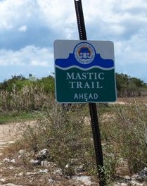
The current proposed route will encroach on significant tracts of land owned by the National Trust, not only threatening the limited remaining pristine natural habitat supporting much of Cayman’s endangered endemic flora but also the historically and culturally significant Mastic Trail.
Howard said, however, that during a recent meeting with the National Trust alternative routes had been proposed, which government officials were now examining. Although there may be room for some compromise, he said, it appeared it would not be enough to save the trail, which may, if the project goes ahead, find itself under a concrete by-pass.
The Trust has already stated that it is not willing to give up its land and while government has the power to compulsorily purchase private land, the Trust has extra protections over land vested under its ownership. As a result, government may find itself in a significant legal battle with the NGO, which is the only non-government body in Cayman that has the will and some funding to preserve the country’s dwindling natural resources.
While government passed the National Conservation Law in an historic victory at the end of last year, which will force its own hand into placing conservation on an equal footing with economic gain, the failure of Cabinet to complete the other necessary legislative changes to support it and finish the regulations has left the critically needed law in limbo.
Nevertheless, at Tuesday’s briefing the premier committed to ensuring that an environmental impact assessment would be carried out in relation to the road and it would also be required of the developer before the project got the go-ahead from planning.
See the MOU and proposed road extension below, as well as a map showing possible alternative alignments of the east-west arterial proposed by the Trust.