Atlantic produces timely reminder of hurricane season
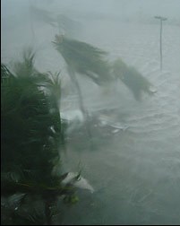 (CNS): In what is proving to be a very peaceful hurricane season so far for the Atlantic, the second tropical depression of the 2009 season formed in the far eastern tropical Atlantic today. However, although things remain relatively calm on the weather front, experts are quick to remind those living in the region not to let their guard down as we enter the peak period for storm formation. According to the National Hurricane Centre in Miami (NHC), satellite images at 6:00am (AST) showed the second tropical depression of the season had formed around 280 miles west of the southernmost Cape Verde Islands.
The depression is moving toward the west at a13 mph and the NHC said its general motion is expected to continue for the couple of days. With maximum sustained winds near 30 and higher gusts, the NHC said it could become the seasons first named tropical storm within a day or two.
Last week the National Oceanic and Atmospheric Administration (NOAA) Climate Prediction Centre (CPC) lowered its Atlantic forecast for 2009 to a near to below normal hurricane season, as a result of the calming effects of El Niño. However, scientists said the season’s quiet start does not guarantee quiet times ahead. The season, which began June 1, is entering its historical peak period of August through October, when most storms form.
“While this hurricane season has gotten off to quiet start,” said Commerce Secretary Gary Locke. “It’s critical that … people are prepared in case a hurricane strikes.”
Forecasters said there is a 70 percent chance of seven to 11 named storms, of which three to six could become hurricanes, including one to two major hurricanes — category 3, 4 or 5. The main change from the May outlook is that fewer named storms and hurricanes are now expected. The May outlook called for nine to 14 named storms, of which four to seven could become hurricanes. The recent forecast for the return of El Niño – warmer than normal waters along the equatorial central and eastern Pacific Ocean – have come to fruition and is already affecting the upper-level atmospheric pressure and winds across the l tropics.
Gerry Bell, Ph.D, lead seasonal hurricane forecaster at NOAA’s Climate Prediction Center, explained the relationship with hurricanes. “El Niño produces stronger upper-level westerly winds over the Caribbean Sea and tropical Atlantic Ocean, which help to reduce hurricane activity by blowing away the tops of growing thunderstorm clouds that would normally lead to tropical storms,” he said.
Officials in both the US and locally, however, are keen to stress that while El Niño may mean fewer storms compared to recent seasons, it doesn’t mean people can let down their guard.
History reveals that hurricanes do hit even during an El Niño, such as Betsy in 1965, Camille in 1969, Bob in 1991, Danny in 1997 and Lili in 2002. Even though El Niño tends to decrease the number of storms, other climate factors may help to create some storms. Thecalm start to this hurricane season is not a reliable indicator of the overall activity for the entire season. The 1992 Atlantic hurricane season, for example, had a below normal number of named storms and hurricanes and the first storm did not form until late August, when Hurricane Andrew hit southern Florida as a destructive category 5 storm.

Category: Science and Nature

I for one welcome the storms and hope Mother Nature takes a kind eye to this Rock we all live on.
CJ
Ahhhhhhhhhhhhhhhhhhhhhhhhhhhhhh!!!!!!!!!!!!!!!!!!!!!!!!!!
Don’t panic…………………………