TD2 pops back up to become Tropical Storm Ana
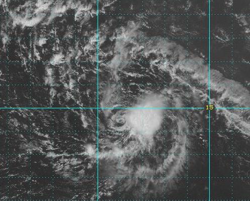 (CNS): (Updated Sunday 8am) — Having dissipated some time in the early hours of Friday morning, Tropical depression two regenerated on Saturday morning and has since developed into the Atlantic’s first tropical storm of the 2009 Hurricane season. At 8am AST on Sunday morning Ana was located about 470 miles east-southeast of the Leeward Islands and moving at a rapid 20 miles per hour.
Storm force winds extend outward up to 70 miles from the centre and the NHC had issued a tropical storm watch for Puerto Rico, US Virgin Island, British Virgin Islands, Montserrat, Antigua, Barbuda, St. Kittts, Nevis, Anguilla, St. Maarten, Saba and St. Eustatius.
Following close behind Ana is Tropical Storm Bill which formed on Saturday evening and by Sunday 5am AST Bill was about 1640 miles east of the Lesser Antilles. Bill is predicted to become a hurricane in the next few days and if ANA doesn’t stengthen it will be come the first of the 2009 Atlantic season.
The NHC said the storm was moving near 13 mph and a gradual turn toward the west-northwest with an increase in forward speed was expected during the next 24 to 48 hours. M
The Hazard Management Cayman Islands (HMCI) reminded residents yesterday that we are entering the peak period of the season for storm activity despite the relatively calm early part of the season. Historical statistics show a dramatic increase in tropical cyclone activity beginning in early August and a steep decline in activity towards the end of October. Ninety six percent of the major hurricane days on record have occurred within this window.
On 14 August 1969 Hurricane Camille which was to become the strongest hurricane to hit the US main land (still) on record, formed as a tropical disturbance north west of the Cayman Islands. Crossing Cuba late on 15 Aug Camille emerged in the southern Gulf of Mexico with 100 mph winds.
By mid day on the 16 Aug reports from reconnaissance aircraft indicated that the storm had slowed, but was intensifying with sustained winds having reached 115 mph. By early evening, Camille was barely moving, but was intensifying rapidly with winds near 150 mph. By late in the afternoon on the 16th, an estimated 200,000 people fled from the US central Gulf coast, while 50 civil defence shelters were opened. By 17 August the tightly knotted vortex of Camille was measuring winds at 190-mph, with gusts over 220-mph. Camille’s 200 mph wind gusts and 25 foot storm surge, destroyed 100 years of growth and progress along the Mississippi coast in only three hours.
Hurricane Andrew in 1992) destroyed more property, and Hurricane Katrina resulted in many more fatalities in the US but Hurricane Camille remains the strongest storm to ever enter the United States mainland on record. Several other category 5 hurricanes in the Atlantic, and super-typhoons in the Pacific, have been as intense. However, unlike many of these super-storms that remained far out to sea, or weaken before making landfall – Camille struck land when at this rare intensity.

Category: Science and Nature
