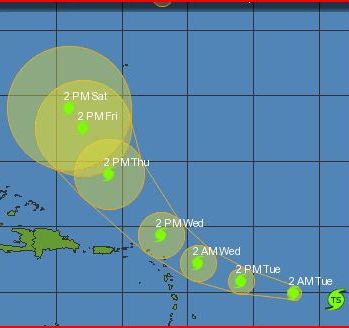
 (CNS): Tropical Storm Fiona formed this evening some 890 miles east of the Leeward Islands. Maximum sustained winds are 40 mph and it is moving west at 24 mph. A turn toward the west-northwest is expected on Tuesday followed by a turn toward the northwest and a decrease in forward speed on Wednesday. The National Hurricane Centre said on this track Fiona could be near or just to the northeast of the northern Leeward Islands by early Wednesday. Some strengthening is forecast during the next 48 hours and tropical storm force winds currently extend outward up to 140 miles to the northeast of the centre. Meanwhile, at 9pm this evening Earl was located about 100 miles of San Juan, Puerto Rico.
Earl is moving toward the west-northwest near 15 mph this general motion is expected to continue tonight followed by a turn toward the northwest on Tuesday. On the forecast track the centre of Earl will move away from the Virgin Islands tonight and pass east of the Turks and Caicos Islands on Tuesday night and Wednesday. Maximum sustained winds are 135mph with higher gusts and additionally strengthening is forecast the NHC said. Hurricane force winds extend outward up to 70 miles from the centre and tropical storm force winds extend outward up to 200 miles.
As Fiona and Earl continue to pose a threat to the region Danielle weakened to a tropical storm over the open Atlantic. As the storm headed towards Newfoundland this evening winds were 70 mph and as Danielle increases speed further weakening is expected. The system is expected to begin losing its tropical characteristics this evening but Danielle will still remain a large and powerful cyclone over the far north Atlantic for the next day or so as tropical storm force winds extend outward up to 275 miles.
Category: Science and Nature
(CNS): Tropical Storm Fiona formed this evening some 890 miles east of the Leeward Islands. Maximum sustained winds are 40 mph and it is moving west at 24 mph. A turn toward the west-northwest is expected on Tuesday followed by a turn toward the northwest and a decrease in forward speed on Wednesday. The National Hurricane Centre said on this track Fiona could be near or just to the northeast of the northern Leeward Islands by early Wednesday. Some strengthening is forecast during the next 48 hours and tropical storm force winds currently extend outward up to 140 miles to the northeast of the centre. Meanwhile, at 9pm this evening Earl was located about 100 miles of San Juan, Puerto Rico.

