Tropical storm races towards Lesser Antilles
 (CNS): The third storm of the 2013 Atlantic Hurricane season was racing towards the Lesser Antilles on Sunday night at 26mph as governments in the eastern Caribbean issued weather warnings. At 11pm Tropical Storm Chantal had formed over the central tropical Atlantic and was headed west-north-westward with maximum sustained winds of 40 mph. Forecasters said the same rapid speed westward or west-north-westward was expected to continue during the next couple of days.
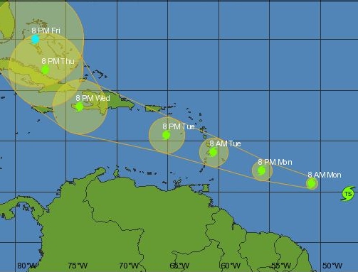
According to the predicted pathway, Chantal should pass north of Cayman Brac next Friday.
Chantal was due to approach the Lesser Antilles late Monday night or early Tuesday and move into the eastern Caribbean sea on Tuesday. Maximum sustained winds are near 40 mph but some strengthening is forecast during the next 48 hours. Tropical storm force winds extend outward up to 60 miles from the centre.

Category: Science and Nature

What about those damaged buildings from Paloma in the Brac that are a hazzard to the neighbours, are government going to help fix them up?
Would have been good to see the story, "New Doplar Radar Picks up Storm"……but I suspect they have yet to actually turn it on….
Afterall Mr Expert, the storm is only 1,740 miles away. Surely a radar with a 400 km range should pick that up.
Guy get your facts right no radar in the world could pick it up being that far away.
18:02, what facts did I present? None.
Do I claim to be an expert. Nope.
So what do I need to get straight?
SSM345 In your initial post you seem to suggest that the radar in Cayman should be able to pick up a storm east of the Caribbean. Or was that my imgination when you said "Would have been good to see the story, "New Doplar Radar Picks up Storm"……but I suspect they have yet to actually turn it on…". Plus it was noted that the radar was already online.
its already on and works great too.
Agree. It's strange — for several days, the weather site crownweather was featuring a radar graphic that was Cayman-centric, right beneath the Cuban Radar Mosaic. Now, the site doesn't show Cayman radar. Was Cayman radar made such that only a few could acess it, or did it break down?
Check the Cayman radar at http://www.weather.gov.ky
click on the image to get a few other choices.
Crownweather or any other site has been using Cuban radars which are tremendously misleading as we are on the outer bounds of the range. That means what the radar is seeing is in excess of 20,000 ft up.
Now we have a cayman radar with much better data.
And for those other questions it is available to all via the Government network.
Much appreciated!!! There it is, our own Cayman radar. With Jamaican radar, our own (finally!) and the Cuban mosaic, this area is very well covered.