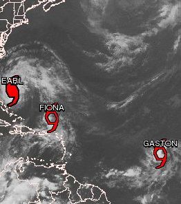
 (CNS): Gaston became the seventh named tropical storm of the 2010 Atlantic hurricane season this evening, and the fourth storm in less than two weeks. Gaston, which is rolling across the ocean in the wake of Tropical Storm Fiona and Hurricane Earl, began slowing down on Wednesday night and NHC forecasters say that the storm is set to strengthen over the next few days. At 11:00pm the centre of Tropical storm Gaston was about 935 miles west of the Cape Verde Islands and some 1585 miles east of the Lesser Antilles. TS Gaston is moving toward the west near 12 mph and this general motion with a decrease in forward speed is expected over the next couple of days.
Maximum sustained winds are near 40 mph with higher gusts and tropical storm force winds extend outward up to 70 miles. Meanwhile, Hurricane Earl is a category form hurricane again and is now threatening the US mid-Atlantic coast. Located about 520 miles south-southeast of Cape Hatteras, North Carolina, maximum sustained winds are at 140 mph and Earl is moving at 18 mph. A turn to the north is expected on Thursday and the core of the hurricane will approach the North Carolina coast by late Thursday, moving near or over the outer banks Thursday night. The centre is expected to pass near or offshore of the Delmarva Peninsula on Friday.
Earl is a large hurricane with hurricane force winds extending outward up to 90 miles from the centre and tropical storm force winds extend outward up to 230 miles.
Tropical Storm Fiona is moving into the Atlantic toward the northwest t almost 23 mph and the NHC said a decrease in speed is expected during the next 24 hours, followed by a turn toward the north on Thursday night. Maximum sustained winds are near 60 mph with higher gusts and gradual weakening is forecast during the next couple of days. Tropical storm force winds extend outward up to 14 miles but Fiona poses no threat to land on its current track.
Category: Science and Nature
(CNS): Gaston became the seventh named tropical storm of the 2010 Atlantic hurricane season this evening, and the fourth storm in less than two weeks. Gaston, which is rolling across the ocean in the wake of Tropical Storm Fiona and Hurricane Earl, began slowing down on Wednesday night and NHC forecasters say that the storm is set to strengthen over the next few days. At 11:00pm the centre of Tropical storm Gaston was about 935 miles west of the Cape Verde Islands and some 1585 miles east of the Lesser Antilles. TS Gaston is moving toward the west near 12 mph and this general motion with a decrease in forward speed is expected over the next couple of days.


Watch that fella Gaston closely, he remin me of one fella named Ivan who look jus like him.