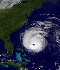
Gaston fades to a remnant as Earl rolls on
 (CNS): As Gaston, the season’s seventh storm faded away this evening, Earl continued on towards the coast of North Carolina. At 8pm it was located some 160 miles southeast of Cape Hatteras. While winds have dropped some to 110mph, Earl remains a large category two hurricane and it is moving at about 18mph. The NHC said a turn towards the north-northeast with an increase in forward speed is expected on Friday. The centre of Earl is forecast to pass near the North Carolina outer banks tonight and approach south-eastern New England by Friday night.
Tropical-storm-force winds are expected to reach the coast within the warning area soon. Even if the centre of Earl remains offshore hurricane force winds are expected to occur in the outer banks overnight tonight, the NHC said. A dangerous storm surge will raise water levels by as much as 3 to 5 feet above ground level within the hurricane warning area over North Carolina and the lower Chesapeake Bay.
Meanwhile, Tropical Storm Fiona is still moving north-northwestward about 425 miles south-southwest of Bermuda where a tropical storm warning is in effect. A turn toward the north is expected tonight with a motion toward the north-northeast forecast by late Friday. On the forecast track the centre of Fiona is expected to pass near Bermuda late Friday or early Saturday. Tropical storm force winds extend outward up to 105 miles to the east of the centre.
Following a pattern of late in the Atlantic, the NHC has also recorded yet another area of law pressure off the Cape Verde Islands could organise itself into a tropical cyclone over the next few days.
Category: Science and Nature

