TS Isaac may cause rough seas over the weekend
 (CNS): Update 11:15am The may be rough seas around Cayman Islands on Saturday and Sunday and it is anticipated that a small craft warning will be in effect over the weekend. However, Hazard Management said that Tropical Storm Isaac does not pose an imminent threat to the Cayman Islands on its current forecast track. Northeast winds of 15 to 20 knot winds are forecast for Saturday and northerly winds of 15 to 20 knots on Sunday. Heavy rainfall is anticipated on Sunday and this could lead to flooding of low lying areas.
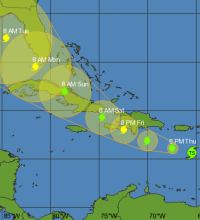
According to the National Hurricane Center in Miami, Florida, at 10am TS Isaac was located near 15.6 N, 65.4 W, or about 200 miles south southeast of San Juan, Puerto Rico. Isaac is moving towards the west near 15 mph with maximum sustained winds near 40 mph. Minimum central pressure is 1003 MB. Storm force winds extend outwards up to 140 miles. Strengthening is forecast and Isaac could to become a hurricane on Friday.

Category: Science and Nature

Is anybody looking at the Satellite views, the hurricane looks like it is going west/south-west, not west,/north-west. They need to update thier models.
Also, a new upate is out since this morning.
No meteorologist, I, however I believe what we are looking at is the convection that has disconnected somewhat from the Center of Circulation, as it runs into a bit of dry air. The COC — at least according to the NHC — has moved every so slightly north of west.
I know. Looks like a southward wobble to me as well. Stay tuned. 😀
anon 1326 was this southwest turn a forecast for the following day?