Storms brew as season moves into busy phase
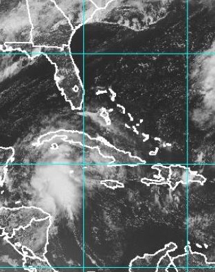 (CNS): Weather experts have warned that conditions in the Atlantic are increasingly likely to spur on storms over the next week as the hurricane season moves into the busy period. Wind shear that can tear budding storms apart has been decreasing, forecasters from a number of weather service centres have said and warned that the potential for more robust tropical waves, the seeds for hurricanes, is increasing. Four storms have already formed in the Atlantic basin this year and activity in the Atlantic is expected to increase next week. The National Hurricane Centre was closely watching several weather systems Wednesday including one south of Cayman which is the source of the current wet and windy local conditions.
This broad area of low pressure in the north-western Caribbean sea is moving toward the west-northwest at 10 to 15 mph. “Cloudiness and showers associated with this low continue to show signs of organization,” the NHC stated Wednesday as it gave the system a 70% chance of becoming a cyclone during the next five days in line with the centre’s new experimental forecasting. “A tropical depression could form before the disturbance reaches the Yucatan peninsula on Thursday,” experts added.
Also cloudiness and showers associated with a low pressure system located a couple of hundred miles southeast of the Cape Verde Islands also remain well organized. “A tropical depression could form later today or on Thursday,” the NHC forecasters stated as they gave that system an 80 per cent chance of becoming a tropical cyclone during the next five days.

Category: Science and Nature
