Second tropical depression stirs up in the gulf
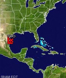 (CNS): A second tropical depression formed in the Gulf of Mexico last night and the National Hurricane Centre is now issuing warnings for the coast of Texas south of Baffin Bay to the Mouth of the Rio Grande and the coast of Mexico from the mouth of the Rio Grande to Rio San Fernando. Although poorly organized the NHC said the tropical depression could become a tropical storm before moving inland today. At 7am this morning (Thursday 8 July) it was moving toward the northwest near 15 mph with maximum sustained winds near 35 mph with higher gusts.
Forecasters said the storm would bring around 4-8 inches of rain over portions of far northeastern Mexico and coastal Texas with isolated maximum amounts of 10 inches.
Meanwhile, in Cayman, the forecast is for patchy cloudiness and isolated showers and some thunder associated with an upper level trough. This trough will linger for the next couple of days. Further east, a tropical wave east of the Cayman area moving west at 2 to 5 knots will move into our area later this evening. Winds will be east to southeast to 5 to 10 knots with higher gusts in and around showers and seas will be slight with wave heights of 1 to 3 feet. Today’s expected High is 87°F – 31°C and the Low: 79°F -26°C

Category: Science and Nature
